SMP Effort Leads to 600-Acre Expansion of Jack London Park
The addition of over 600 acres to the Jack London State Historic Park was the culmination of a seven-year effort led by Sonoma Mountain Preservation (SMP). The transfer of the two upper western parcels of the Sonoma Developmental Center (SDC), which increased the Park’s acreage by over 40 per cent, was celebrated on September 5, 2002.
The future of these parcels first came into question in 1995 when the California Department of General Services (DGS) declared them to be surplus to the needs of the Center. SMP organized a public meeting in February 1996 to discuss the disposition of these ecologically important lands, which, under proposed legislation, would be available for vineyard development. Over 200 citizens attended this meeting and voiced an almost unanimous opinion that the parcels should be maintained in their natural condition and added to the Park.
The legislation was amended to include an option to sell or exchange the two parcels in a transaction that would result in their becoming part of Jack London Park. The following year the Sonoma County Agricultural Preservation and Open Space District (OSD) chaired a public meeting where once again public settlement remained the same: open space for the two parcels. In Sacramento DGS continued working toward an agricultural lease on the lower parcel which included the “old orchards” and the old growth redwood tree.
In January 1998 a break-through came when the Sonoma County Board of Supervisors approved OSD’s purchase of a forever-wild easement over the upper of the two parcels as a coast of $255,000. At a public meeting in January 1998, attended by over 250 people, there was again opposition to an agricultural lease over the lower “old orchards” parcel.
In the fall of 2000, an environmental consultant contracted by the DGS began work on a two-year land-use feasibility study for the “old orchards” parcel, which could have resulted in a multiplicity of suggested uses and opened the way for intensive agriculture, and possible sale of house sites below Fern Lake. By December, DGS had reversed its position to concentrate solely on the conversion of “old orchards” to vineyards.
In February 2001, with tremendous effort by legislative members Wiggins, Nation and Chesbro, transfer of the two parcels to Jack London State Park became the goal. By June 2001, the land-use feasibility study concluded that the State Park would be the optimum organization to have control and oversight over the lower parcel. The study cited the Park Department’s ability to protect both the watershed and historical and natural resources of the land. The transfer of the two parcels to Jack London State Historic Park took place.
In August 2002, the Sonoma Ridge Trail, a segment of the Bay Area Ridge Trail system, was dedicated on the upper of the two transferred parcels.
The Triangle G (Galvin) Ranch consisted of six parcels which stretched about six miles along the southern ridge of Sonoma Mountain from south of the Route 116 at an elevation of less than 400ft to the northern highest point of 1946 feet about one mile south of the top of Sonoma Mountain. John Galvin bought the Circle W Ranch from George and Mildred Webb in 1954. That Ranch, plus additional parcels later purchased, was known as the Triangle G Ranch. John Galvin, an Australian, worked in Asia for many years as a newspaper reporter. After World War II he got involved in commercial ventures in Asia and ended up making an estimated $375 million. Galvin brought his wife and five children to Woodside, California in 1952 according to San Francisco Chronicle articles. John Galvin is deceased and his five children now own the ranch.
Proposed Subdivision
In December, 1996, Redwood California LTD, a Galvin property managed by Bill Brittain, applied to Sonoma County to subdivide five parcels and place 34 building lots in the northern area clustered along the ridge line from 1200 feet of elevation to 1900 feet of elevation where they would be visible from both sides of the mountain. The applicant requested: amendment of the County General Plan, change in zoning, exemption from the regulations governing clustering, and transferring housing destiny into a scenic landscape area. These were among the many problems with the proposed subdivision, which they called the White Oak Estates.
Opposition
In 1997 a committee of volunteer residents of Sonoma Mountain was formed with Ray Barron, Chairman, Stephen Pavy, Treasurer, and John Barinaga, Secretary, to lead opposition to the ridge-top development. There was widespread opposition to the subdivision. The committee met periodically with Supervisor Mike Cale who was clear in his opinion that the proposed projects should not be allowed because it would set a very bad precedent. On February 2, 1997, the Petaluma City Council voted unanimously to ask the County Board of Supervisors not to approve the project as proposed. On February 19, 1997 the Sonoma City Council voted unanimously to go on record with the County Board of Supervisors not to amend the General Plan or zoning to allow such a development.
On April 29, 1997, the Sonoma County Planning Commission held a public hearing on the Galvin application. About a dozen people from the public spoke on the issue. All speakers, except Mr. Morrison, the developer, spoke in opposition to the project for specific reasons. The committee, the George Ranch representative and Sonoma Mountain Preservation, all presented written analysis of the non-compliance aspects of the application
Revision with Park Proposal
A revision to the White Oak Estates project was submitted to Sonoma County Permit and Resource Management Department in March 2000. The revised proposal offered to dedicate 394 acres of the Galvin Ranch for a park and offered to sell an additional 266 acres at a price to be negotiated on exchange for the County’s granting of permission for the 34 home subdivision on the ridge of Sonoma Mountain (in violation of the County General Plan) and the County’s provision of the access road by extending Manor Lane. The Environmental Impact Report revision was never completed because the applicant failed to provide funding.
The OSD Offer to Purchase
With the spring of 2001 came the good news that the Galvin family would consider selling the bulk of Triangle G Ranch rather than developing it. The Sonoma County Open Space District and the California Coastal Conservancy confirmed in April that they were in negotiations to acquire most of the 1746-acre ranch. Since the original application for subdivision was submitted to the county, the parcel south of State Gulch Road was sold and another 96 acres were leased to the UCC Vineyards Group and planted in grapes.
In January 2002 the Open Space District offer to buy 1626 acres to the Galvin family with the right to build two homes. This ended our hopes, and the hopes of the county supervisors, that the threat of ridge top development would end with the purchase. We do not know what the Galvin family will do with the ranch in the future. Presently the ranch is used for cattle grazing and for grape growing.
There is no more controversial property on Sonoma Mountain than the Lafferty Ranch. For many years it has been the object of a struggle between those want to open it to public access as a park and those who want no public access. SMP has constantly supported its opening to the public. The battle ranges on.
Geographical Setting
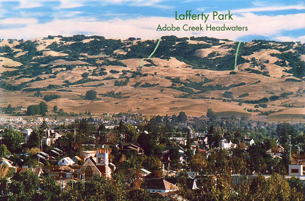
Lafferty Ranch is a 270-acre parcel (APN 136-170-001 and SMP Map B31) owned by the City of Petaluma on the southwest slope of Sonoma Mountain Road (west). It is highly visible from Petaluma, sighting directly up E. Washington Street in the center of town Elevations on the parcel range from 1000’ to the ridgeline at 2200’. It comprises most of the headwaters of historic Adobe Creek, the most reliable water source on the west mountain, and thus a wildlife oasis in summer and fall, as well as the largest riparian oak woodland on the Petaluma side. It is bordered by large private parcels, one of which controls the only road access, Sonoma Mountain Road.
History
Photo by Scott Hess courtesy of Friends of Lafferty Park
1870s: A portion of the Vallejo rancho, with boundaries as they are today, is sold to pioneer homesteader Marshall Lafferty. For the next 80+ years the property passes through several hands as a working ranch and private watershed (at one time, additional water was brought via pipeline form Copeland Creek at what is now Fairfield-Osborne preserve).
1959: The City of Petaluma purchases the private water company, which includes Lafferty Ranch and the downslope Lawler Reservoir. The express intent is to continue to operate Lafferty as watershed, with eventual conversion to parkland. The park goal is reflected in city and county planning documents in the early 1960s.
1992: Lawler Reservoir is deemed seismically unsafe by the state of CA, making Lafferty Ranch obsolete as an “extractive” watershed. New neighbor Peter Pfendler offers to buy Lafferty from the City of $675,000. The City Council rejects the offer and takes steps to open Lafferty Ranch to the public. Pflendler threatens legal action, and the Council balks. The first Lafferty Ranch support group, Citizens for Access to Lafferty Ranch, is formed with organizational help from Sonoma County Conservation Action.
1993: Peter Pflender purchases Moon Ranch, a parcel on the lower mountain, and proposes to trade it to the county for a regional park (with funding from the new Open Space District) in exchange for Petaluma giving him Lafferty Ranch. The pros and cons of this offer are debated heatedly in the ensuing three years.
1996: Reflecting vigorous grassroots organizing by the renamed Citizens for Lafferty Ranch and a Regional Park (CLRRP), the Press Democrat publishes a poll showing Petaluma residents oppose the “Swap” 3-1, with most listing “Lafferty is irreplaceable” as their primary reason. It is an election year, and the City Council immediately starts to back away from privatizing Lafferty.
CLRRP launches a “Keep Lafferty” initiative to open Lafferty and collects 5,600 signatures in a few weeks, but this initiative is ultimately disqualified on a technicality (failure to properly notice start of a petition drive).
Pfendler officially withdraws the “swap” proposal. The City Council then enacts Ordinance 2022, which commits the city to keeping Lafferty Ranch in public ownership and to opening it for public enjoyment.
In the November City Council elections, the three open seats are won by proponents of opening Lafferty, achieving a majority for that policy on the Council.
1997: Petaluma forms a citizens’ committee to create an access and management plan for Lafferty Park, a prelude to an EIR.
Late 1990s: Petaluma works to complete a huge EIR for Lafferty Park in the face of constant legal opposition from Mr. Pfendler’s attorneys and consultants. Lafferty also figures in “proxy wars” involving parks and trails in western Sonoma Mountain in the county’s Outdoor Recreation Plan (which is still not finalized), and in Acquisition Plans for the Open Space District.
2001: The Petaluma City Council certifies the 2000 page EIR for an open space park at Lafferty Ranch. In the face of legal threats, it postpones the next step of approving the project, citing lack of funds (mostly for legal fights), and lack of County support.
2002: In the face of legal threats and the inability to solve the access problem from Sonoma Mountain Rd., the City of Petaluma has not allowed even limited public access to Lafferty Ranch since around 1995. The renamed Friend of Lafferty Park organizes a series of “Walks to the Park,” 7-miles road walks from downtown Petaluma up Sonoma Mountain Road to the gate of Lafferty Ranch.
Petaluma also formally requests that the Open Space District purchase the development rights to Lafferty Ranch to ensure its open space character in perpetuity and to give the city funds to proceed with park opening. The OSD rejects the request on the basis that Lafferty is already public land (despite the fact that it had done a similar deal at the Sonoma Developmental Center) and not in immediate danger of being surplussed.
2003: Landowner Mary Mitsui offers a public trail across her mountaintop property if a way can be found to connect it to Jack London State Historic Park and the Lafferty Ranch. See the separate chronology from Bill Kortum on this topic.
2007: The stalemate continues. The Petaluma City Council has not taken on the obstructing neighbors. It also continues to reject privatization, the threat of which is still there. And there is still no public access, which is blocked by the neighbors who both control the entry from Sonoma Mountain Rd. and have made it clear that they would fight public access in the courts. Petaluma looks up at 10,000 acres on its side of Sonoma Mountain, and there is still not a single public trail or acre of parkland in all that expanse. But there are some new developments. Three of the neighbors, including Peter Pflender, have recently died, and the future of their properties is unclear. Will new owners continue to oppose the desire of two generations of Petaluma’s to open Lafferty as a public park? SMP is monitoring these developments closely.