Join us for these spring hikes!
Explore the Foot of Sonoma Mountain—Frogs, Burrowing Owls, and Late Flowers
Lafferty Ranch at a Slow, Deep Pace
Explore the Foot of Sonoma Mountain—Frogs, Burrowing Owls, and Late Flowers
Friday, May 8th
10 am to 2 pm
Description: Join us to explore the wildflower-covered, low, undulating hills at the foot of Sonoma Mountain! Riley Scaff, Sonoma Land Trust’s stewardship staff, will guide us.
We’ll walk first up into the hills to see the wildflowers and great views. We’ll learn about burrowing owl restoration work, then head down to see some wetlands and SLT’s frog restoration work.
3-4 miles round-trip, with 360′ of elevation. Hills are low but steep.
Meet at Sears Point Trailhead, 7699 Reclamation Road off Highway 37. See directions below.
This hike is another rare opportunity to experience the foot of Sonoma Mountain, looking out to the Bay and restored wetlands.
Some conditions to be aware of:
• The highway underpass is a little low, so most people need to crouch to get through it. It can get muddy under there, too.
• We won’t follow a discernible trail, so expect grassy, uneven terrain. Good footwear is a must. Ticks will be out, so long pants are a must as well. Recommend gaiters or tucking pant legs into socks.
• It’s a working cattle ranch, so cattle could be in one of the pastures we walk through. They’re totally docile and will get out of the way when they see we don’t have hay.
• Definitely bring hiking poles because of uneven terrain.
Hike Leaders: Madeline Kellner and Larry Modell from the SMP Board will join Riley Scaff from SLT in leading the hike
Logistics: Children are OK, but they should be able to walk the distance (3-4 miles) independently. Bring your lunch and water. Pets and smoking are not permitted. Heavy rain cancels.
Maximum 25 people. Participants must sign a waiver upon arrival
Directions: Sears Point Trailhead, 7699 Reclamation Road, Sonoma, CA 95476, at the stoplight intersection of Lakeville and Hwy 37. Parking area on left of Reclamation Road. We will carpool to hike site. Detailed directions will be sent in a reminder email.
Google Maps link to Sears Point Trailhead.
REGISTER

Photo by Gale Yeager, April 2025, at last year’s Foot of the Mountain hike.
Lafferty Ranch at a Slow, Deep Pace
Sunday, May 17th
9 am to 12 pm
Description: Have you wished you could visit beautiful Lafferty Ranch without taking a long hike? This is the outing for you! Along with fabulous views—of the Petaluma Valley, Mount Tamalpais, and San Francisco Bay— we’ll explore the land through slow, silent walking, guided visualizations, and prompts to connect with the land, and perhaps a “sit spot” where you can listen, rest, draw, write, or simply be on the mountain. We will be walking no more than a mile on relatively flat terrain, although there are some uneven trails. You’ll be invited to deepen your relationship with trees and lichen, soil and stones, Adobe Creek, and Sonoma Mountain itself.
This is a joint hike with our partner organization, LandPaths. We’ll talk a bit about the land’s history, SMP’s role in protecting Sonoma Mountain’s wildlands, and how Petaluma’s Lafferty Ranch project fits into the mountain’s preservation.
Hike Leaders: Meg Beeler and Eberle Ewing
Logistics: You will be asked to sign a liability waiver upon arrival. No restrooms available. This is a rustic property. Please plan accordingly.
Click on the link below to register and for more information.
REGISTER

RECENT HIKES
Annual New Year hike on the East Slope Trail
TENTATIVELY RESCHEDULED FOR JANUARY 10th.
(dependent on weather)
10 am to 2:30 pm
Description: Join Sonoma Mountain Preservation Board members on the East Slope Trail of Sonoma Mountain for a rare guided hike with special access and gorgeous views.
We’ll have a leisurely climb through private property, stopping to explore a forest of Buckeye trees and volcanic soils. We’ll enjoy fabulous views of Sonoma Valley, Sonoma Developmental Center, the Mayacamas, Mt. Tam, Petaluma River watershed, San Pablo Bay, and Mt. Diablo.
Approximate 800-foot elevation gain, then relatively level ridge trail along the E. Slope conservation easement to the South Loop at Jack London State Historic Park and back, about 4 miles total.
At the beginning we’ll walk in silence, allowing us to sink into a wild creature’s perspective of the sounds and smells, Buckeye and Bay trees, meadows and Live oaks, and the Valley below.
Hike Leaders: SMP board members Nancy Kirwan and Meg Beeler.
Logistics: Outdoor “facilities.” Bring plastic to sit on, lunch, water, walking sticks, boots,
a journal, and layers. Arrive at the carpool location early, at 9:45. Return by 2:30 PM. Maximum 5 cars, 25 hikers. Heavy rain cancels, with reschedule on Saturday, January 10th.
Directions: Meet 9:45 on Grove Street between Picazzo Cafe and 1041 Grove Street, going west,
just past Bonneau’s Store off Arnold Drive, in Sonoma. Parking is limited where we’re
headed. We will caravan at 10 AM.
REGISTER
Lafferty Ranch – Slow Pace Hike
JANUARY 25th.
1 pm to 4 pm
Description:
Have you wished you could visit beautiful Lafferty Ranch without taking a long hike? This is the outing for you! Along with fabulous views—of the Petaluma Valley, Mount Tamalpais, and San Francisco Bay— we’ll explore the land through slow, silent walking, guided visualizations, and prompts to connect with the land, and perhaps a “sit spot” where you can listen, rest, draw, write, or simply be on the mountain. We will be walking no more than a mile on relatively flat terrain, although there are some uneven trails. You’ll be invited to deepen your relationship with trees and lichen, soil and stones, Adobe Creek, and Sonoma Mountain itself.
This is a joint hike with our partner organization, LandPaths. We’ll talk a bit about the land’s history, SMP’s role in protecting Sonoma Mountain’s wildlands, and how Petaluma’s Lafferty Ranch project fits into the mountain’s preservation.
Hike Leaders: Meg Beeler, Madeline Kellner, and Eberle Ewing
Logistics: You will be asked to sign a liability waiver upon arrival. No restrooms available. This is a rustic property. Please plan accordingly.
Click on the link below to register and for more information.
REGISTER
Van Hoosear Wildflower Preserve
Tuesday, April 14th
10 am to 12:30 pm
This hike is full, but you can sign up for the waitlist. We often have cancellations.
Also, check out our other hikes.
Waitlist
Description: The Van Hoosear Wildflower Preserve is a 163-acre field on the lower slopes of Sonoma Mountain. Every year an extraordinary array of wildflowers bursts forth in the fields with different species on display at different times of the spring. Thanks to the Goode family for sharing access to the property and to SEC for co-managing it, we will be leading one of the few hikes at the preserve this year. Don’t miss your chance and join us to experience this fleeting spectacle. There is also a chance we will see song birds, raptors, coyotes, and many butterflies.
It will be a leisurely 2-mile hike with a brief uphill at the beginning. Be prepared for walking through tall grass with ticks, and for stepping across small creeks. These hikes fill up fast, so sign up early.
Hike Leaders: Sarah Reid, Nancy Kirwin
Logistics: Wear sturdy shoes, light colored pants, and gaters or socks you can tuck your pants into. Bring your camera/phone, water, a hat, sunscreen, a snack, and binoculars if you wish. Sorry, no dogs are allowed on the property.
Directions: We will meet at the green and white barn at 2303 Grove Street, west of Arnold and on the south side of Grove Street. There is plenty of parking. The hike will be cancelled if there is steady rain.
REGISTER

Fairfield Osborn Preserve Sudden Oak Death (SOD) Blitz
Saturday, April 18th
10 am to 1 pm
Registration HERE
Description: This SOD bioblitz is in partnership with Sonoma State University’s Center for Environmental Inquiry.
Help control this destructive forest pathogen! Now in its 19th year, this statewide community science project is vital to managing Sudden Oak Death, which is widespread in Sonoma and Mendocino counties. Join SSU students and staff in contributing to this ongoing citizen science project. Thanks to support from SMP, three student researchers in Dr. Lisa Hua’s Biology Department lab will also present their research on how infection influences the Bay Laurel genome, which may, in turn, affect host susceptibility or disease progression.
On the preserve, we will start with a 15-minute presentation by the Biology students, then walk to different spots to collect leaves and record basic data in teams of two or three people. We will be walking on dirt paths that have varied terrain to accommodate different levels of fitness. Collected samples will be sent to the UC Berkeley Forest Pathology Lab for analysis. Participants can see the 2025 SOD Blitz results online at https://sites.google.com/berkeley.edu/matteogarbelottolab/sod.
Hike Leaders: Kerry Wininger, Jason Romero, Jillian Gonzales, Claudia Tellez
Logistics: All equipment will be provided, and no previous experience is required. Parking is limited so please consider carpooling. A restroom, sink for hand-washing, and potable water are available on site. Participants must sign a waiver upon arrival. This event is appropriate for minors 12 years and older. All minors must be accompanied by a legal guardian
Please read the registration page carefully to learn what you need to bring and how you need to prepare for this event.
Directions: Fairfield Osborn Preserve is a 15-minute drive from Sonoma State University’s main campus, on Lichau Road in Penngrove. Driving directions are available here English and Spanish
The Unique Habitat of the Sonoma Mountain Vernal Pools
Tuesday, April 28th
9 am to 12 pm
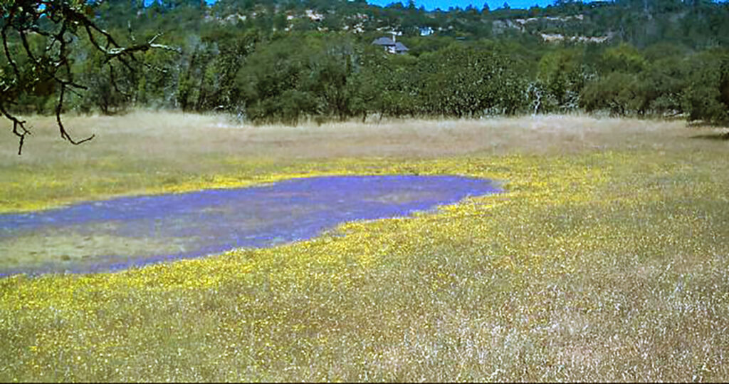
Description: This year, we will be touring the Sonoma Mountain Vernal Pools a week earlier than last year. The different weather patterns of this last year will give us a new experience. The property’s two large montane vernal pools are a distinct type of wetland that supports plant species found nowhere else in the country. In late spring, the pools begin to dry, transforming into colorful concentric circles, a fairy ring display of wildflowers, including rare
ones such as Sonoma sunshine, Baker’s navarretia, and dwarf downingia. Sonoma Land Trust purchased this unique property to both protect the vernal pools and their distinctive plants and to add a link in the series of properties that make up the Sonoma Valley wildlife corridor that stretches from Lake Berryessa to the coast.
We will hike through mature oak woodlands, virgin grasslands, and a section of Yulupa Creek in this open space on the north side of Sonoma Mountain. There are no trails, but lots of flowers.
Hike Leaders: SLT staff and SMP board members
Logistics: It is advisable to wear good hiking shoes, long light colored pants, and gaiters or socks you can tuck your pants into to ward off ticks. Additionally, consider bringing water, binoculars, a phone/camera, walking sticks, a hat, and a snack. The tour will last around 2.5 hours. Sorry, no dogs are allowed on the property.
Directions: We will meet at 9:00 am at the southern parking lot for Jack London Village (Closest to SDC) just south of
the town of Glen Ellen. The address is 14301 Arnold Drive. We will have a van that carries nine, but due to the limited parking on site, the rest of us will need to carpool to Bennett Valley Road and Enterprise Road from the parking lot.

Eldridge Marsh, Connections and Explorations
Saturday, May 2nd
10 am to 12 pm
Description: Tucked between the eastern boundary of the now-shuttered campus of the former Sonoma Developmental Center and Sonoma Highway in Glen Ellen, what’s locally known as the Eldridge Marsh had been sequestered since the Nuns Fire blew through in 2017. This wild freshwater marshland has been transferred to California State Parks and preserved as part of a chain of open spaces that make up a delicate and endangered pinch point in the Sonoma Valley Wildlife Corridor. Now open to the public, this outing offers an opportunity to explore one of the last remaining pockets of freshwater marshland in the upper Sonoma Valley. We’ll take a look at its unique flora and fauna while uncovering the cultural and natural history that shapes this landscape.
This easy, mostly flat, 2+-mile walk circles the marsh on a paved road, features stellar views of Sonoma Mountain and the Mayacamas, and is suitable for explorers of all ages. A representative from California State Parks may also be on hand to talk about the agency’s plans for the marsh and surrounding open space.
Hike Leaders: Steve Lee, Senior Scientist and Research Program Manager with the Sonoma Ecology Center, and Tracy Salcedo, SMP Board Chair.
Logistics: You will be asked to sign a liability waiver upon arrival. No restrooms are available; please plan accordingly.
You will receive a confirmation email upon registration. If you do not receive an email, you are not registered for the outing. Dogs are not allowed on the property. Only heavy rain will cancel; please be prepared to walk in light rain.
Bring: Water and snacks, comfortable walking shoes that can get wet, a hat, camera, journal, field guides.
Directions: Park along Harney Drive on the campus of the former Sonoma Developmental Center in Glen Ellen. We’ll meet at the gate at the junction of Harney with Railroad.
Connect with SMP
Sonoma Mountain – The Book!

Where the World Begins: Sonoma Mountain Stories and Images draws you into our inspiring natural treasure at the heart of southern Sonoma County. Local Bestseller, IPPY Award 2020. Two purchasing choices below: